Doklam Satellite Images
- All
- News
- Videos
-

After Satellite Pics Show China's Inroads Near Doklam, India's Response
- Friday July 22, 2022
- India News | Reported by Vishnu Som, Edited by Debanish Achom
India on Thursday said it keeps an eye on all developments having a bearing on national security, days after NDTV accessed new satellite images that indicate that a Chinese village in Doklam is now fully inhabited.
-
 www.ndtv.com
-

Pics Expose China's Inroads Near Doklam - Bid To Bypass Indian Defences?
- Wednesday July 20, 2022
- India News | Written by Vishnu Som
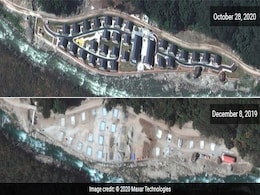
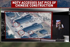
New satellite images accessed by NDTV indicate that a Chinese village, constructed 9 km East of the Doklam plateau where Indian and Chinese forces faced off in 2017, is now fully inhabited with cars parked at the doorstep of virtually every home.
-
 www.ndtv.com
-

New Chinese Ammunition Bunkers Seen 7 Km From 2017 Doklam Face-Off Site
- Monday November 23, 2020
- India News | Written by Vishnu Som
Satellite imagery accessed by NDTV shows the construction of what appear to be military-grade, hardened ammunition bunkers, 2.5 kilometres away from Sinche-La pass on the eastern periphery of the contested Doklam plateau near the border between Bhutan and China in the area.
-
 www.ndtv.com
-

Exclusive: Satellite Images Hint At Renewed China Threat In Doklam
- Sunday November 22, 2020
- India News | Written by Vishnu Som
High resolution satellite imagery accessed by NDTV indicates that in addition to setting up a village more than two kilometres within Bhutanese territory on the eastern periphery of the contested Doklam plateau, China has built a road in the same area that stretches approximately 9 kilometres inside Bhutanese territory.
-
 www.ndtv.com
-

Exclusive: China Building New 'Tunnels' For Winter At Border Hotspot Doklam
- Monday November 9, 2020
- India News | Written by Vishnu Som
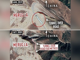
China has stepped up its road construction activity in the Doklam plateau to ensure that all-weather access is maintained in the region, where India and China were involved in a nearly 70-day stand-off in 2017, indicates a satellite image accessed by NDTV.
-
 www.ndtv.com
-

Will Build Doklam Infrastructure, Says Aggressive China After Satellite Pics
- Friday January 19, 2018
- India News | Edited by Nidhi Sethi
Almost five months after India and China ended a 70-day standoff in Doklam, the satellite images have shown a full-fledged Chinese military complex being built within the region, China said that India has no business to comment on construction activity on Chinese territory
-
 www.ndtv.com
-

Full-Fledged Chinese Military Complex In Doklam, Show Satellite Pics
- Wednesday January 17, 2018
- India News | Written by Vishnu Som
A massive, full-fledged Chinese military complex is being built within Doklam, show new satellite images five months after India and China ended a 70-day standoff in the region that lies to the east of Sikkim.
-
 www.ndtv.com
-

Exclusive: In Doklam, Chinese Built New Roads In Last 2 Months, Show Satellite Pics
- Tuesday December 12, 2017
- India News | Written by Vishnu Som
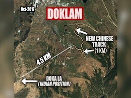
New satellite images of the Doklam area to the east of Sikkim clearly indicate that Chinese road workers have expanded multiple stretches of the existing track in the disputed area, a short distance away from the site where Indian and Chinese soldiers faced off for 70 days earlier this year.
-
 www.ndtv.com
-

Exclusive: How China Has Built Major Roads In Doklam
- Wednesday October 11, 2017
- India News | Written by Vishnu Som
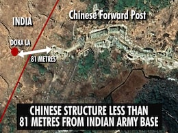
High-res satellite images accessed by NDTV show that China has, over the last decade, been steadily converting tracts of land in the disputed Doklam Plateau into full-fledged all-weather roads that run a few hundred metres from Indian posts such as Doka La in Sikkim.
-
 www.ndtv.com
-

After Satellite Pics Show China's Inroads Near Doklam, India's Response
- Friday July 22, 2022
- India News | Reported by Vishnu Som, Edited by Debanish Achom
India on Thursday said it keeps an eye on all developments having a bearing on national security, days after NDTV accessed new satellite images that indicate that a Chinese village in Doklam is now fully inhabited.
-
 www.ndtv.com
-

Pics Expose China's Inroads Near Doklam - Bid To Bypass Indian Defences?
- Wednesday July 20, 2022
- India News | Written by Vishnu Som
New satellite images accessed by NDTV indicate that a Chinese village, constructed 9 km East of the Doklam plateau where Indian and Chinese forces faced off in 2017, is now fully inhabited with cars parked at the doorstep of virtually every home.
-
 www.ndtv.com
-

New Chinese Ammunition Bunkers Seen 7 Km From 2017 Doklam Face-Off Site
- Monday November 23, 2020
- India News | Written by Vishnu Som
Satellite imagery accessed by NDTV shows the construction of what appear to be military-grade, hardened ammunition bunkers, 2.5 kilometres away from Sinche-La pass on the eastern periphery of the contested Doklam plateau near the border between Bhutan and China in the area.
-
 www.ndtv.com
-

Exclusive: Satellite Images Hint At Renewed China Threat In Doklam
- Sunday November 22, 2020
- India News | Written by Vishnu Som
High resolution satellite imagery accessed by NDTV indicates that in addition to setting up a village more than two kilometres within Bhutanese territory on the eastern periphery of the contested Doklam plateau, China has built a road in the same area that stretches approximately 9 kilometres inside Bhutanese territory.
-
 www.ndtv.com
-

Exclusive: China Building New 'Tunnels' For Winter At Border Hotspot Doklam
- Monday November 9, 2020
- India News | Written by Vishnu Som
China has stepped up its road construction activity in the Doklam plateau to ensure that all-weather access is maintained in the region, where India and China were involved in a nearly 70-day stand-off in 2017, indicates a satellite image accessed by NDTV.
-
 www.ndtv.com
-

Will Build Doklam Infrastructure, Says Aggressive China After Satellite Pics
- Friday January 19, 2018
- India News | Edited by Nidhi Sethi
Almost five months after India and China ended a 70-day standoff in Doklam, the satellite images have shown a full-fledged Chinese military complex being built within the region, China said that India has no business to comment on construction activity on Chinese territory
-
 www.ndtv.com
-

Full-Fledged Chinese Military Complex In Doklam, Show Satellite Pics
- Wednesday January 17, 2018
- India News | Written by Vishnu Som
A massive, full-fledged Chinese military complex is being built within Doklam, show new satellite images five months after India and China ended a 70-day standoff in the region that lies to the east of Sikkim.
-
 www.ndtv.com
-

Exclusive: In Doklam, Chinese Built New Roads In Last 2 Months, Show Satellite Pics
- Tuesday December 12, 2017
- India News | Written by Vishnu Som
New satellite images of the Doklam area to the east of Sikkim clearly indicate that Chinese road workers have expanded multiple stretches of the existing track in the disputed area, a short distance away from the site where Indian and Chinese soldiers faced off for 70 days earlier this year.
-
 www.ndtv.com
-

Exclusive: How China Has Built Major Roads In Doklam
- Wednesday October 11, 2017
- India News | Written by Vishnu Som
High-res satellite images accessed by NDTV show that China has, over the last decade, been steadily converting tracts of land in the disputed Doklam Plateau into full-fledged all-weather roads that run a few hundred metres from Indian posts such as Doka La in Sikkim.
-
 www.ndtv.com


