






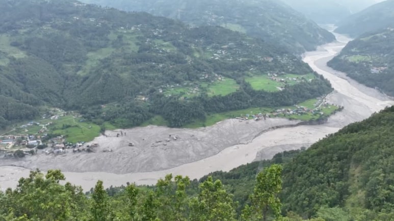
We rebuilt the bridge. The river took it again.
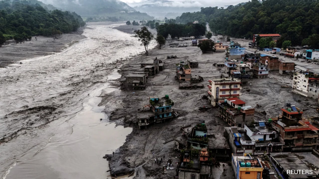
The Nepal-China Friendship Bridge across the Bhote Koshi was destroyed by a glacial lake outburst flood in July 2025 and was reconstructed. On August 26, 2026, a massive rock-and-ice avalanche near the Nepal-Tibet border sent another catastrophic surge down the same valley; it was not a glacier collapse. The bridge is reportedly gone again. So is much of what stood in that corridor: villages, customs yards, hydropower stations, a showcase 25-megawatt solar plant in Nuwakot buried under sediment, and hundreds of lives.
That single fact - the same bridge, the same valley, thirteen months apart - should unsettle every policymaker in Kathmandu, Delhi, and Beijing. We are rebuilding in the path of a hazard chain we have not understood, using assumptions about mountain stability that the mountains themselves keep disproving.
What Happened
At 8:37 AM Nepal time, a massive section of glacier and rock broke away at approximately 5,200 metres from the north face of Langtang Lirung, a 7,245-metre peak located wholly within Nepal, 45 kilometres north of Kathmandu. The United States Geological Survey (USGS) initially registered it as a magnitude 4.4 earthquake before correcting itself. No earthquake had occurred. The seismic signal, equivalent to a magnitude 5.2 event, was the collapse itself. The emerging scientific picture is that this was not primarily a glacier collapse. Goran Ekstrom, seismologist at Columbia University's Lamont-Doherty Earth Observatory, analysed data from the Global Seismographic Network and found that the Lhende Khola event was a landslide - one of the largest anywhere in the world in the past decade or two. The bedrock beneath the glacier failed, and the glacier ice broke away as part of the slope failure. As Ekstrom put it, the glacier just came along for the ride.
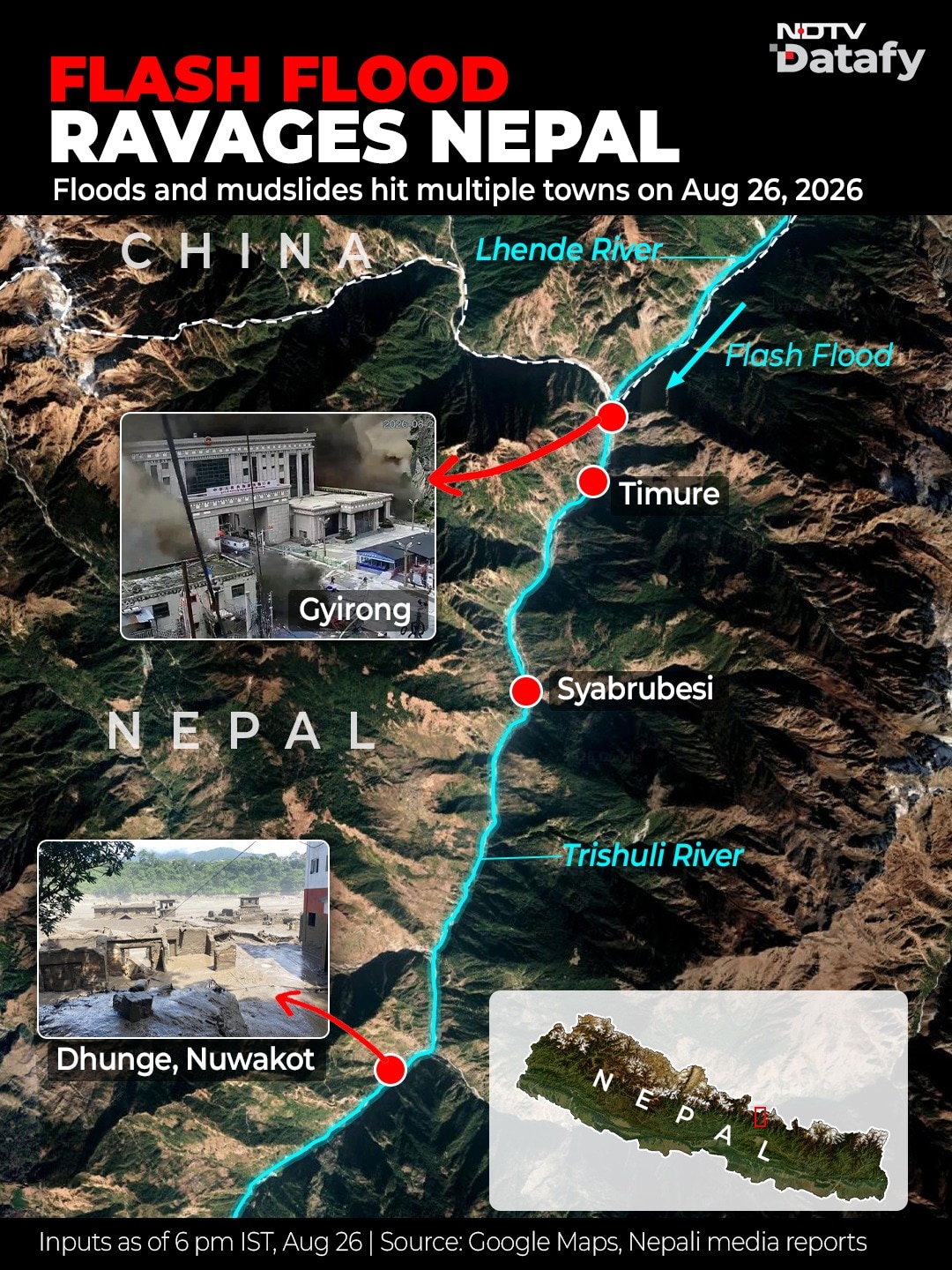
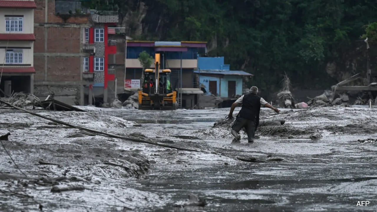
What happened next is not in dispute. The debris descended approximately 1,200 metres and entered the Lhende Khola, blocking the monsoon-swollen river. When the impounded water burst through, it sent a torrent of water, mud, ice, and rock into the Bhote Koshi. CCTV footage from the border immigration post shows buildings engulfed in seconds. Water levels on the Trishuli rose nine metres in 30 minutes. By afternoon, Bihar had opened the Gandak Barrage gates and evacuated nearly 5000 people from six districts.
More than 900 people are confirmed dead across Nepal and Tibet. Over 5,000 remain missing, including 288 Indians on the Kailash Yatra. Thirteen hydropower projects were affected and six directly damaged, removing roughly 431 megawatts, about 8% of Nepal's generating capacity, from the grid in a single morning. A barrier lake formed by collapsed debris upstream is rising and at risk of bursting. Bodies and debris were seen floating down the Narayani, 200 kilometres downstream, by the following morning.
Tibet to Nepal to India. One glacier. Three countries. One river system. Everywhere the water went, it arrived before the warning.
Also read: Why Did Viral Nepal House Survive Flood When Others Fell? X Video Explains
The Warning That Went Backwards
In July 2025, when a flood struck this same corridor, Chinese authorities reportedly warned Nepal. This year, no warning reached anyone.
That should sit for a moment. On the same river system, 13 months apart, the cross-border information chain did not improve but regressed. And the problem is structural. China has shared no hydrological data with India since 2022. The bilateral arrangement for Brahmaputra flood-forecasting data expired in June 2023 and has not been renewed. When the physics of a transboundary hazard can move from Tibet to Bihar in hours, the absence of shared real-time data is not a diplomatic inconvenience but a threat to life.
This data deficit is about to grow more consequential. China's approval of the Medog hydropower project on the Yarlung Tsangpo has dominated Indian headlines as a 'water bomb' threat. But as Dr Anamika Barua, Professor of Ecological Economics at IIT Guwahati, has argued, the framing misses the point. The real risk to the Brahmaputra is not a single dam but the convergence of seismic hazards, landslides, climate extremes, and changing flows in a mountain system growing less stable by the year. India's priority should be better upstream data, early warning, and transboundary cooperation, not alarmism. What August 26 demonstrates is what happens when it does not.
The Pattern
The Himalaya has been sending versions of this signal for over a decade. Kedarnath, 2013: extreme monsoon rainfall and a moraine-dammed lake. Over 5,000 dead. Chamoli, 2021: 27 million cubic metres of rock and glacier ice collapsing from Ronti Peak with no glacial lake involved, becoming a debris flow that killed more than 200. South Lhonak, Sikkim, 2023: a classic glacial lake outburst from a lake that had expanded 45% in seven years. Thame in 2024 and Bhote Koshi in July 2025. And now Bhote Koshi again.
Each disaster had a different trigger. Each followed a different hazard chain. That is precisely the problem. Dr Thamban Meloth, Director of India's National Centre for Polar and Ocean Research (NCPOR), put it directly in one of his interviews: there is no one-size-fits-all early warning system for the Himalayas. What happened in Nepal was not what happened in Sikkim. Each valley has its own geology, its own microclimate, and its own failure modes. You cannot monitor glacial lakes alone and assume you have covered the risk, because the mountains can produce catastrophic floods without a lake being involved at all.
Dr Ashim Sattar, glaciologist at IIT Bhubaneswar and lead author of recent research on Himalayan ice instability, sees a direct line between Chamoli and August 26. This was essentially a similar type of event, he said - a rock-and-ice collapse from a steep, unstable face, not a simple glacier collapse. The difference is the order of magnitude and the ice and rock volumes. Nepal Himalaya sits in the central Himalayan belt, as does Uttarakhand. Sattar and co-authors' research, published in npj Natural Hazards earlier this year, identified 219 hanging glaciers in the Alaknanda Basin alone - glaciers perched on steep slopes that can detach without warning. These are hazards that have been systematically underresearched. We focus on glacial lakes and debris flows, he noted, but hanging glaciers represent a class of potential hazard that needs more attention.
And our models cannot see these events coming. Most prediction models operate at grid sizes of around 10 square kilometres. An extreme mountain event can unfold within less than an hour. As Dr Thamban noted, we simply do not have enough instruments across all these areas, and our model predictions are only as good as the data we feed into them.
Why It Is Getting Worse
Snow cover across the Hindu Kush Himalaya had fallen 27.8% below the long-term average earlier this year, the lowest in over two decades. Snow acts as a protective layer over glaciers. When it is insufficient, glaciers begin melting earlier and more aggressively. Preliminary analysis by climate scientists indicates summer warming near Langtang Lirung of approximately 0.29 degrees Celsius per decade since 1940, totalling roughly 2.5 degrees. July 2026 was the second-warmest July on record.
Permafrost, the frozen ground that cements mountain slopes together, is thawing. At 5,000 to 6,000 metres, this releases loose rock and gravel that had been locked in place for millennia. Dr Thamban described what follows: the gravitational energy makes it devastating. You get a mixture of ice, rocks, water, and everything else. It is like wet concrete. Yet permafrost remains the least studied component of the Himalayan cryosphere.
The Nepal disaster makes this concrete. The bedrock that failed on August 26 was almost certainly held together, in part, by permafrost and glacial ice that is no longer there. As Ekström noted, in areas where glaciers are disappearing, these landslides are occurring more frequently. The glacier did not directly cause the catastrophe, but its absence may have.
And there is feedback most people have never heard of. As glaciers retreat and snow disappears, darker rock and water absorb more solar energy, accelerating further warming, which accelerates further melting. One major study estimated this albedo feedback contributed approximately 2.6 degrees of amplified warming in the Himalaya. The cryosphere is not simply melting. In some areas, its loss is speeding up its own destruction.
Over 5,000 glacial lakes now exist across the region. More than 200 are classified as potentially dangerous. India has identified 189 high-risk glacial lakes, with 56 at very high risk. Recent research projects that glacial lakes will nearly triple in extent from their 2000 baseline. The central Himalayas, within India, account for 40% of that projected expansion.
Also read: Reporter's Diary | Roads Were Gone, We Kept Going: 6 Days Through Flood, Debris And Death In Nepal
What Has Been Done, And Where The Gaps Remain
India launched the National Glacial Lake Outburst Flood Risk Mitigation Programme (NGRMP) in 2024 with a budget of 150 crore rupees across four states. It has been monitoring 902 glacial lakes via remote sensing since 2022. The Ministry of Earth Sciences is developing improved AI-based prediction models. These are tangible steps.
But the gaps are severe. At South Lhonak, the lake had been identified as dangerous before it burst. A water-level sensor installed in 2016 failed after six months. The lake burst in October 2023 without an operational ground-based warning system. If a sensor cannot survive where the danger exists, what exactly are we monitoring? And 150 crore rupees for a hazard stretching across thousands of kilometres of the most inaccessible terrain on Earth is a fraction of what the problem demands.
Meanwhile, there is evidence from the same region that a different approach works. China operationalised its Glacial Lake Management System (GLMS) in 2019, combining automated monitoring, engineering interventions at lake sites, and dedicated on-site personnel. Before the system, China experienced 31 GLOFs between 2005 and 2019, with six causing significant damage. After operationalisation: four events, minimal damage, zero deaths. In the same period, 16 GLOFs outside China killed or affected over 60 people and destroyed over 26,000 buildings.
What Must Change
The solutions are specific and, in several cases, already proven. The expired data-sharing arrangements between China and India must be renewed. An automated, real-time alert mechanism for transboundary river corridors is needed, one that transmits across borders without waiting for diplomatic clearance for each event. If China could warn Nepal of the 2025 flood but no warning reached anyone in 2026, the system has failed.
Monitoring instruments must be engineered to survive extreme high-altitude conditions, maintained by trained personnel, and backed by redundant systems. A sensor that fails after six months and goes unreplaced for seven years is not a monitoring system. Hazard mapping must extend from source to valley floor, covering GLOF inundation, debris-flow pathways, and avalanche runout, overlaid with settlements and infrastructure. Where existing infrastructure sits in a catastrophic corridor, relocation must be on the table.
Warning times in these events can be less than 30 minutes. Communities need localised evacuation plans, designated safe zones, and regular drills. And permafrost and ground-warming assessments should be mandatory in project reports for high-altitude infrastructure. The familiar cycle of disaster, reconstruction in the same location, and repeat disaster must be broken.
What The Ice Keeps Telling Us
I have been inside a glacier. In April 2023, I fell into a crevasse on Annapurna and spent three days at 70 metres depth, held alive by the cold of ancient ice. I came out understanding that glaciers are not static backdrops. They are dynamic systems that interact with everything around them - weather, rock, water, communities, and the infrastructure we place in their path.
August 26 is an early chapter in a story the mountains have barely begun to tell. The conditions that produced this disaster are all intensifying. Less than 0.1% of global climate finance reaches glaciers. Nepal contributes 0.1% of global emissions but bears some of the highest climate risk on Earth. The mountains that supply water to over two billion people receive a fraction of the attention directed at oceans and forests. What we need now is cryosphere justice: the recognition that the frozen landscapes of the high mountains are critical infrastructure for human survival and that monitoring them and preparing the communities that depend on them cannot wait for the next disaster to force the conversation.
The Lhende Khola has now flooded twice in fourteen months. The bridge has been rebuilt and destroyed twice. The science is clear. The question is whether governments will act on what they already know - or whether, the next time this valley floods, we will once again be counting the same preventable losses and rebuilding the same bridge.
(The author is a mountaineer and founder and CEO of The Voice of Glaciers Foundation (TVGF), working on cryosphere justice and disaster preparedness in the Hindu Kush Himalaya (HKH). He is a World Economic Forum Young Global Leader, 2025. In April 2023, he survived 72 hours trapped in a glacial crevasse at 6,000 metres on Annapurna.)
Disclaimer: These are the personal opinions of the author

