






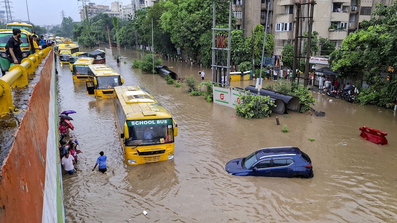
Every monsoon, Gurugram is confronted with the same paradox. A city celebrated as one of India's most modern urban economies can be brought to a standstill by a few hours of intense rainfall. Roads become channels, underpasses become reservoirs, and traffic corridors become temporary floodplains.
It is tempting to describe this as a drainage failure. But that explanation is incomplete. Gurugram's recurring flooding is fundamentally a failure to plan the city as a hydrological system.
The geography of Gurugram has always demanded a particular relationship with water. The Aravallis form the higher ground along the southern and eastern edges of the urban region, while the terrain falls towards the north and northwest. Historical drainage patterns carried water through seasonal channels, depressions, ponds, and natural drains towards the Najafgarh system. Studies have identified an elevation difference of roughly 60 to 70 metres between the Aravalli foothills and the Najafgarh basin, creating a natural gradient for the movement of stormwater.
The problem is that the contemporary city has progressively obscured this geography.
Water Follows Topography, Not Master Plans
A city may be divided into sectors, plots, and infrastructure zones, but rainwater does not recognise these boundaries. It follows slope, soil, permeability, and gravity.
This is why the idea that Gurugram can solve flooding simply by adding larger drains is inadequate. A drainage network is the final component of a catchment system, not a substitute for one.
When open land becomes concrete, the hydrological equation changes.
On natural ground, rainfall is divided between infiltration, evaporation, temporary storage, and surface runoff. On a heavily paved urban surface, a much larger proportion becomes immediate runoff. The greater the impervious area, the faster water reaches the drainage network, and the higher the peak discharge becomes.
In engineering terms, the issue is not simply the total quantity of rainfall. It is the rate point at which rainfall is converted into runoff and the timing of that runoff reaching a drainage system.
That distinction is crucial.
A recent GIS and SWMM-based study of Gurugram examined eight high-runoff sub-catchments and found that a combination of green roofs, permeable pavements, and rainwater storage could reduce runoff volume by as much as 72.31% and peak discharge by 54.05%.
These are not aesthetic interventions. They are hydrological infrastructure.
We have confused water removal with water management.
For decades, the dominant approach to urban stormwater has been straightforward: collect water as quickly as possible and move it somewhere else.
That model is becoming increasingly inadequate. A resilient city follows a different hierarchy:
retain > infiltrate > reuse > convey > discharge
The first four stages should happen as close as possible to where rainfall occurs. Only the residual water should enter the larger drainage network.
This requires restoring the city's blue-green infrastructure: ponds, wetlands, natural depressions, open channels, recharge areas, planted corridors, and permeable landscapes. These should not be considered recreational or leftover spaces. They are components of the city's hydraulic system.
Research on Gurugram has demonstrated the potential of precisely this approach. One recent study proposed integrating retention ponds into the existing drainage network and found substantial reductions in simulated flood volumes under both regular and extreme rainfall scenarios.
The lesson is important: the landscape itself can be infrastructure.
The Next Masterplan
The real opportunity for Gurugram lies not merely in constructing more drains but in changing how future development is evaluated.
Every major development proposal should answer four basic questions:
- What is the catchment?
- How much additional impervious surface will the development create?
- How much additional runoff and peak discharge will it generate?
- Where will that water be retained, infiltrated, or safely conveyed?
This requires moving towards catchment-level stormwater modelling, using high-resolution Digital Elevation Models, rainfall intensity data, soil characteristics, land-use and land-cover data, drainage capacity, and existing water bodies.
GIS and hydrological models such as EPA-SWMM can then simulate how different development scenarios perform under varying rainfall intensities. This should become part of the development approval itself.
A building should not be assessed only for its Floor Area Ratio, parking, access, and fire safety. In a flood-prone urban region, its hydrological footprint should matter as well.
Roads Must Be Part Of The Solution
Gurugram's roads present another opportunity.
Instead of treating every road edge as a hard boundary between carriageway and drain, selected corridors can incorporate bioswales, rain gardens, permeable shoulders, depressed landscape areas and temporary detention zones. Parking areas can incorporate permeable surfaces wherever soil and groundwater conditions permit.
The objective is not to eliminate conventional drains. It is to reduce the hydraulic load placed upon them.
This is particularly important as rainfall patterns become more uncertain. A drainage system designed around historical rainfall statistics may perform adequately under an old climate regime but fail when rainfall arrives in shorter, more intense bursts.
A Gurugram-specific study comparing increasing imperviousness with increasing rainfall intensity found that climate change could be the more severe threat to drainage-system performance, with the combination of urbanisation and more intense rainfall further worsening the risk.
That should fundamentally change how we design infrastructure.
Not A Yearly Reckoning
Gurugram does not need another cycle of monsoon flooding followed by emergency pumping, desilting, road repairs, and the identification of new flooding hotspots.
It needs a long-term urban flood resilience strategy.
That strategy should begin with mapping the city's complete hydrological network, including natural drains and historical water bodies. It should identify flood pathways and protect them from further encroachment. Existing ponds and retention areas should be restored as functioning stormwater infrastructure. New developments should be required to demonstrate their post-development runoff performance. And critical infrastructure should be designed against future rainfall scenarios, not simply historical averages.
Most importantly, the responsibility for stormwater cannot remain confined to one municipal agency. Roads, planning, land development, water, drainage, and environmental authorities must work from a common hydrological map.
The fundamental principle is simple.
We cannot continue building over the landscape and then ask the drainage system to compensate for what the landscape once did naturally.
Gurugram's flooding is thus not simply a question of insufficient drains. It is a question of whether we understand the relationship between land, water, and urbanisation.
The city has the technology to model its catchments, the engineering capacity to redesign its infrastructure, and the economic resources to implement both. What it now needs is a change in planning philosophy.
The most resilient Gurugram will not be the one with the largest drains. It will be the one that allows its landscape to perform its original function: to slow water down, absorb what it can, store what it cannot, and safely convey the rest.
(The author is a noted architect and urban planner. He is the Managing Principal of CP Kukreja Architects)
Disclaimer: These are the personal opinions of the author

