


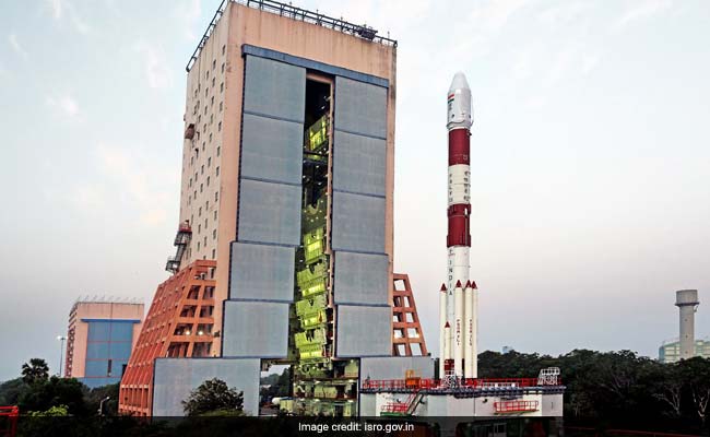
ISRO's IRNSS-1I Launch: PSLV-C41 rocket will lift-off from the first launch pad in Sriharikota
New Delhi:
Less than a fortnight after ISRO launched home-made communications satellite GSAT-6A, the space agency is geared up to launch its independent and home-made navigation satellite IRNSS or Indian Regional Navigation Satellite System. Though the March 29 launch of the GSAT-6A saw a major setback after scientists lost connection with the satellite, ISRO seems undeterred and is focusing on its latest launch - IRNSS-1I - which will be launched on board the PSLV-C41 rocket. The PSLV or Polar Satellite Launch Vehicle is ISRO's most reliable and versatile workhorse and will carry the IRNSS-1I on its forty-third flight.
When Is The PSLV-C41/IRNSS-1I Launch Scheduled?
ISRO has scheduled the PSLV-C41/IRNSS-1I mission launch for Thursday. The launch will happen at 04:04 am IST on April 12, 2018.
What Is The PSLV-C41/IRNSS-1I Launch? What Will It Do?
In its forty-third flight, the Polar Satellite Launch Vehicle PSLV-C41 will launch the IRNSS-1I from the first launch pad (FLP) of the Satish Dhawan Space Centre (SDSC) at the Sriharikota High Altitude Range (SHAR) in Andhra Pradesh's Sriharikota. The IRNSS-1I launch will happen in XL configuration on board the PSLV rocket. This will be the twentieth time that the PSLV's 'XL' configuration will be used for a launch. The IRNSS-1I will be the eighth satellite to join ISRO's NavIC navigation satellite constellation. The 8th navigation satellite IRNSS-1I will be a replacement in the NavIC constellation for the 1,425kg IRNSS-1H, whose launch was unsuccessful.
What Are The Previous IRNSS Navigation Satellites That Have Been Launched By ISRO As Part Of The NavIC Satellite Cconstellation?
The previous IRNSS missions to have joined ISRO's NavIC navigation satellite constellation are IRNSS-1A (launched on July 01, 2013), IRNSS-1B (launched on April 04, 2014), IRNSS-1C (launched on October 16, 2014), IRNSS-1D (launched on March 28, 2015), IRNSS-1E (January 20, 2016), IRNSS-1F (launched on March 10, 2016), IRNSS-1G (launched on April 28, 2016), and IRNSS-1H (launched on August 31, 2017). All the launches except IRNSS-1H have been successful. Their purpose is to build India's self-made navigation system - similar to the US' GPS or Global Positioning System. The orbit of some of the IRNSS satellites are geo-stationary or GEO, while some are geo-synchronous or GSO. Please see the table below for reference.
 What Happened To The IRNSS-1H Satellite? Why Was The Launch Unsuccessful?
On August 31, 2017, ISRO launched the IRNSS-1H to join its NavIC navigation satellite constellation. IRNSS-1H was planned to be launched by PSLV-C39 into a sub Geosynchronous Transfer Orbit (sub-GTO) with a 284 km perigee and 20,650 km apogee with an inclination of 19.2 degrees with respect to the equatorial plane. The lift-off of the PSLV-C39 rocket carrying the IRNSS-1H satellite was normal, however, the mission was unsuccessful as the IRNSS-1H satellite could not be placed into orbit properly. IRNSS-1H had failed to eject out of the PSLV rocket on August 31, 2017 to its intended orbit as its heat shield failed to separate even around 20 minutes after it was launched. The rocket's heat shield should have separated three minutes into the launch, but failed to do so. After a 19-minute wait for the heat shield to separate, ISRO scientists had declared the mission unsuccessful. The 8th navigation satellite IRNSS-1I will be a replacement in the NavIC constellation for the 1,425kg IRNSS-1H.
What Is ISRO's IRNSS Program?
IRNSS is an independent Indian Satellite based positioning system for critical national applications. The main objective is to provide reliable position, navigation and timing services over India and its neighbourhood, to provide good accuracy to the user.
According to ISRO, IRNSS or Indian Regional Navigation Satellite System "is an independent regional navigation satellite system being developed by India. It is designed to provide accurate position information service to users in India as well as the region extending up to 1,500 km from its boundary, which is its primary service area. An Extended Service Area lies between primary service area and area enclosed by the rectangle from Latitude 30 degrees South to 50 degrees North, and Longitude 30 degrees East to 130 degrees East. IRNSS will provide two types of services, namely, Standard Positioning Service (SPS) which is (similar to US' GPS and) provided to all the users, and Restricted Service (RS), which is an encrypted service provided only to the authorised users. The IRNSS System is expected to provide a position accuracy of better than 20 m in the primary service area."
IRNSS will assist in terrestrial, aerial and marine navigation, disaster management, vehicle tracking and fleet management, integration with mobile phones, precise timing, mapping and geodetic data capture, terrestrial navigation aid for hikers and travellers, visual and voice navigation for drivers and riders.
What Is NavIC? Are IRNSS And NavIC The Same Project?
Yes, NavIC and IRNSS are the same project undertaken by India's space agency ISRO. NavIC is the operational name for the IRNSS or Indian Regional Navigation Satellite System. NavIC, which means sailor or navigator in Sanskrit and other Indian languages, stands for Navigation with Indian Constellation (NavIC). The NavIC or IRNSS program will have a dual purpose - commercial and military. The accuracy for the commercial part of the project - to be used by the public - is expected to be better than 20 metres, with some regions offering accuracy up to 10 metres. The accuracy for military use, which will be encrypted, will be as accurate as 0.1 metre. The total number of satellites in the NavIC constellation will be 8 satellites (7 without IRNSS-1A, which is now only partly operational). The orbital height of the IRNSS satellites are 36,000 kilometres above sea level. The total cost of the project (till March 2017) was rupees 2,246 crores or $344 million. ISRO is now planning to expand the NavIC constellation system from 8 to 11 satellites. Apart from NavIC, which is a regional project, India is also planning a global navigation project called Global Indian Navigational System or GINS. A study and analysis in this regard was initiated in the twelfth five-year plan. The system will have a constellation of 24 satellites (apart from IRNSS' 11) and will be positioned at a height of 24,000 km above earth (IRNSS constellation is 36,000 km above earth). In 2013, the statutory filing for frequency spectrum of GINS satellite orbits in international space had been completed.
Which Other Countries / Space Agencies Have Similar Navigational Systems?
India's (ISRO's) NavIC joined the elite league of four countries / space agencies which have similar navigation capabilities. These include GPS (United States), GLONASS (Russia), Galileo (European Union), BeiDou (China). Japan is also planning a similar project with three of its own satellites. Japan's system will be called the QZSS.
Apart From IRNSS/NavIC, Does India's Satellite Navigation System Include Any Other Application?
Yes, apart from IRNSS (NavIC), India's satellite navigation system will also include another commercial and strategic application - GAGAN. Apart from public and military use, ISRO will provide special satellite-based navigation services to meet the emerging demands and requirements of Civil Aviation in India. To meet the Civil Aviation requirements, ISRO is working jointly with Airport Authority of India (AAI) in establishing the GPS Aided Geo Augmented Navigation or GAGAN system. GAGAN is a Satellite Based Augmentation System (SBAS) implemented jointly with Airport Authority of India. The main objectives of GAGAN are to provide Satellite-based Navigation services with accuracy and integrity required for civil aviation applications and to provide better Air Traffic Management over Indian Airspace. The system will be interoperable with other international SBAS systems and provide seamless navigation across regional boundaries. The GAGAN Signal-In-Space (SIS) is available through GSAT-8 and GSAT-10.
What Are Some Of The Salient Features Of The IRNSS-1I Satellite?
The IRNSS-1I will be part of India's NavIC navigation contellation system. It will help in providing navigational and positioning assistance, and its use will be both commercial as well as militray. The IRNSS-1I will transmit signals for the determination of position, navigation and time. It will have L5 and S-band navigation payload with rubidium atomic clocks. It will also have C-band ranging payload as well as corner cube retro reflectors for LASER ranging. The IRNSS-1I will have a lift-off weight of 1,425 kg and an overall size of 1.58m X 1.5m X 1.5m. This will be the ninth navigational satellite launch under the project which has seen seven successful launches and one unsuccessful launch.
How Will The IRNSS-1I Satellite Be Launched? Which Rocket Will Carry The Satellite?
The IRNSS-1I navigation satellite will be launched by ISRO's PSLV-C41 rocket. The Polar Satellite Launch Vehicle or PSLV-C41 will be the forty-third flight of the PSLV rocket or launcher. The launch of the PSLV-C41 carrying the IRNSS-1I will happen from the first launch pad (FLP) of the Satish Dhawan Space Centre (SDSC) at the Sriharikota High Altitude Range (SHAR) in Andhra Pradesh's Sriharikota. The height of the rocket carrying the IRNSS-1I is 44.4 metres and its weight is 321 tonnes.
How Many Stages Will The IRNSS-1I Launch Comprise Of?
The IRNSS-1I launch will have four stages. The first stage is called the 'core' stage (PS1) and will have six strap-on motors (PSOMs). This will be followed by stages two, three and four before the satellite is finally put in orbit. Stages one and three will comprise of composite solid propellant, whereas stages two and four will comprise of Earth storable liquid propellants.
How Long Will It Take For The IRNSS-1I Satellite To Be Put In Orbit?
The total time to put the IRNSS-1I satellite in orbit (IRNSS-1I separation from the rocket) since its lift-off from the launch pad in Sriharikota will be 19 minutes and 19.6 seconds. Here is the flight profile and ground trace trajectory of the PSLV-C41 rocket carrying the IRNSS-1I satellite.
What Are The Technological Details Of The IRNSS-1I Launch?
The targeted Sub-Geosynchronous Transfer Orbit or Sub-GTO of the PSLV-C41 include a 'perigee' (point in the orbit of a satellite at which it is nearest to the earth) of 284 kilometres, an 'apogee' (point in the orbit of a satellite at which it is farthest from the earth) of 20,650 kilometres, an 'inclination' of 19.2 degrees, and an 'azimuth' of 104 degrees. The mission will be the forty-third flight of the PSLV rocket and the twentieth flight of the PSLV-XL version. The launch will include orbit raising manoeuvres using the satellite's onboard propulsion system. The targeted orbit of the IRNSS-1I is aimed at a height of 36,000 kilometres above Earth. It will have a geo-synchronous orbit at an inclination of 29 degrees once in place over the 55 degree East longitude.
The launch of the IRNSS-1I satellite comes fourteen days after the launch of ISRO's communication satellite GSAT-6A, which was put in orbit successfully, but scientists lost communication with it on March 31 when it was on course to its intended slot in the geo-stationary orbit, about 36,000km above the Earth. The Master Control Facility (MCF) of the space agency (ISRO) at Hassan in Karnataka has been trying its best to restore link with the 2,000 kg GSAT-6A satellite since April 1 but has not succeeded till date. Click here to know more about ISRO's GSAT-6A mission.
Here is all you need to know about ISRO's PSLV-C41/IRNSS-1I launch:
When Is The PSLV-C41/IRNSS-1I Launch Scheduled?
ISRO has scheduled the PSLV-C41/IRNSS-1I mission launch for Thursday. The launch will happen at 04:04 am IST on April 12, 2018.
What Is The PSLV-C41/IRNSS-1I Launch? What Will It Do?
In its forty-third flight, the Polar Satellite Launch Vehicle PSLV-C41 will launch the IRNSS-1I from the first launch pad (FLP) of the Satish Dhawan Space Centre (SDSC) at the Sriharikota High Altitude Range (SHAR) in Andhra Pradesh's Sriharikota. The IRNSS-1I launch will happen in XL configuration on board the PSLV rocket. This will be the twentieth time that the PSLV's 'XL' configuration will be used for a launch. The IRNSS-1I will be the eighth satellite to join ISRO's NavIC navigation satellite constellation. The 8th navigation satellite IRNSS-1I will be a replacement in the NavIC constellation for the 1,425kg IRNSS-1H, whose launch was unsuccessful.
What Are The Previous IRNSS Navigation Satellites That Have Been Launched By ISRO As Part Of The NavIC Satellite Cconstellation?
The previous IRNSS missions to have joined ISRO's NavIC navigation satellite constellation are IRNSS-1A (launched on July 01, 2013), IRNSS-1B (launched on April 04, 2014), IRNSS-1C (launched on October 16, 2014), IRNSS-1D (launched on March 28, 2015), IRNSS-1E (January 20, 2016), IRNSS-1F (launched on March 10, 2016), IRNSS-1G (launched on April 28, 2016), and IRNSS-1H (launched on August 31, 2017). All the launches except IRNSS-1H have been successful. Their purpose is to build India's self-made navigation system - similar to the US' GPS or Global Positioning System. The orbit of some of the IRNSS satellites are geo-stationary or GEO, while some are geo-synchronous or GSO. Please see the table below for reference.

As ISRO gears up to launch IRNSS-1I on Thursday morning, here is a list of India's navigation satellites
On August 31, 2017, ISRO launched the IRNSS-1H to join its NavIC navigation satellite constellation. IRNSS-1H was planned to be launched by PSLV-C39 into a sub Geosynchronous Transfer Orbit (sub-GTO) with a 284 km perigee and 20,650 km apogee with an inclination of 19.2 degrees with respect to the equatorial plane. The lift-off of the PSLV-C39 rocket carrying the IRNSS-1H satellite was normal, however, the mission was unsuccessful as the IRNSS-1H satellite could not be placed into orbit properly. IRNSS-1H had failed to eject out of the PSLV rocket on August 31, 2017 to its intended orbit as its heat shield failed to separate even around 20 minutes after it was launched. The rocket's heat shield should have separated three minutes into the launch, but failed to do so. After a 19-minute wait for the heat shield to separate, ISRO scientists had declared the mission unsuccessful. The 8th navigation satellite IRNSS-1I will be a replacement in the NavIC constellation for the 1,425kg IRNSS-1H.
What Is ISRO's IRNSS Program?
IRNSS is an independent Indian Satellite based positioning system for critical national applications. The main objective is to provide reliable position, navigation and timing services over India and its neighbourhood, to provide good accuracy to the user.
According to ISRO, IRNSS or Indian Regional Navigation Satellite System "is an independent regional navigation satellite system being developed by India. It is designed to provide accurate position information service to users in India as well as the region extending up to 1,500 km from its boundary, which is its primary service area. An Extended Service Area lies between primary service area and area enclosed by the rectangle from Latitude 30 degrees South to 50 degrees North, and Longitude 30 degrees East to 130 degrees East. IRNSS will provide two types of services, namely, Standard Positioning Service (SPS) which is (similar to US' GPS and) provided to all the users, and Restricted Service (RS), which is an encrypted service provided only to the authorised users. The IRNSS System is expected to provide a position accuracy of better than 20 m in the primary service area."
IRNSS will assist in terrestrial, aerial and marine navigation, disaster management, vehicle tracking and fleet management, integration with mobile phones, precise timing, mapping and geodetic data capture, terrestrial navigation aid for hikers and travellers, visual and voice navigation for drivers and riders.
ISRO will launch the IRNSS-1I on board the PSLV-C41 rocket on Thursday morning at 04:04 am IST
Yes, NavIC and IRNSS are the same project undertaken by India's space agency ISRO. NavIC is the operational name for the IRNSS or Indian Regional Navigation Satellite System. NavIC, which means sailor or navigator in Sanskrit and other Indian languages, stands for Navigation with Indian Constellation (NavIC). The NavIC or IRNSS program will have a dual purpose - commercial and military. The accuracy for the commercial part of the project - to be used by the public - is expected to be better than 20 metres, with some regions offering accuracy up to 10 metres. The accuracy for military use, which will be encrypted, will be as accurate as 0.1 metre. The total number of satellites in the NavIC constellation will be 8 satellites (7 without IRNSS-1A, which is now only partly operational). The orbital height of the IRNSS satellites are 36,000 kilometres above sea level. The total cost of the project (till March 2017) was rupees 2,246 crores or $344 million. ISRO is now planning to expand the NavIC constellation system from 8 to 11 satellites. Apart from NavIC, which is a regional project, India is also planning a global navigation project called Global Indian Navigational System or GINS. A study and analysis in this regard was initiated in the twelfth five-year plan. The system will have a constellation of 24 satellites (apart from IRNSS' 11) and will be positioned at a height of 24,000 km above earth (IRNSS constellation is 36,000 km above earth). In 2013, the statutory filing for frequency spectrum of GINS satellite orbits in international space had been completed.
Which Other Countries / Space Agencies Have Similar Navigational Systems?
India's (ISRO's) NavIC joined the elite league of four countries / space agencies which have similar navigation capabilities. These include GPS (United States), GLONASS (Russia), Galileo (European Union), BeiDou (China). Japan is also planning a similar project with three of its own satellites. Japan's system will be called the QZSS.

ISRO's IRNSS-1I satellite will join seven other similar satellites in India's NavIC constellation
Yes, apart from IRNSS (NavIC), India's satellite navigation system will also include another commercial and strategic application - GAGAN. Apart from public and military use, ISRO will provide special satellite-based navigation services to meet the emerging demands and requirements of Civil Aviation in India. To meet the Civil Aviation requirements, ISRO is working jointly with Airport Authority of India (AAI) in establishing the GPS Aided Geo Augmented Navigation or GAGAN system. GAGAN is a Satellite Based Augmentation System (SBAS) implemented jointly with Airport Authority of India. The main objectives of GAGAN are to provide Satellite-based Navigation services with accuracy and integrity required for civil aviation applications and to provide better Air Traffic Management over Indian Airspace. The system will be interoperable with other international SBAS systems and provide seamless navigation across regional boundaries. The GAGAN Signal-In-Space (SIS) is available through GSAT-8 and GSAT-10.
What Are Some Of The Salient Features Of The IRNSS-1I Satellite?
The IRNSS-1I will be part of India's NavIC navigation contellation system. It will help in providing navigational and positioning assistance, and its use will be both commercial as well as militray. The IRNSS-1I will transmit signals for the determination of position, navigation and time. It will have L5 and S-band navigation payload with rubidium atomic clocks. It will also have C-band ranging payload as well as corner cube retro reflectors for LASER ranging. The IRNSS-1I will have a lift-off weight of 1,425 kg and an overall size of 1.58m X 1.5m X 1.5m. This will be the ninth navigational satellite launch under the project which has seen seven successful launches and one unsuccessful launch.

ISRO's IRNSS-1I satellite will be launch on board the PSLV-C41 rocket on Thursday morning
The IRNSS-1I navigation satellite will be launched by ISRO's PSLV-C41 rocket. The Polar Satellite Launch Vehicle or PSLV-C41 will be the forty-third flight of the PSLV rocket or launcher. The launch of the PSLV-C41 carrying the IRNSS-1I will happen from the first launch pad (FLP) of the Satish Dhawan Space Centre (SDSC) at the Sriharikota High Altitude Range (SHAR) in Andhra Pradesh's Sriharikota. The height of the rocket carrying the IRNSS-1I is 44.4 metres and its weight is 321 tonnes.
How Many Stages Will The IRNSS-1I Launch Comprise Of?
The IRNSS-1I launch will have four stages. The first stage is called the 'core' stage (PS1) and will have six strap-on motors (PSOMs). This will be followed by stages two, three and four before the satellite is finally put in orbit. Stages one and three will comprise of composite solid propellant, whereas stages two and four will comprise of Earth storable liquid propellants.
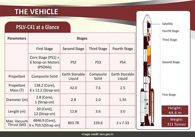
ISRO's PSLV-C41 rocket will launch navigation satellite IRNSS-1I in a 4-stage manoeuvre
The total time to put the IRNSS-1I satellite in orbit (IRNSS-1I separation from the rocket) since its lift-off from the launch pad in Sriharikota will be 19 minutes and 19.6 seconds. Here is the flight profile and ground trace trajectory of the PSLV-C41 rocket carrying the IRNSS-1I satellite.

Here's the flight profile and ground trace trajectory of the PSLV-C41 rocket carrying IRNSS-1I satellite
The targeted Sub-Geosynchronous Transfer Orbit or Sub-GTO of the PSLV-C41 include a 'perigee' (point in the orbit of a satellite at which it is nearest to the earth) of 284 kilometres, an 'apogee' (point in the orbit of a satellite at which it is farthest from the earth) of 20,650 kilometres, an 'inclination' of 19.2 degrees, and an 'azimuth' of 104 degrees. The mission will be the forty-third flight of the PSLV rocket and the twentieth flight of the PSLV-XL version. The launch will include orbit raising manoeuvres using the satellite's onboard propulsion system. The targeted orbit of the IRNSS-1I is aimed at a height of 36,000 kilometres above Earth. It will have a geo-synchronous orbit at an inclination of 29 degrees once in place over the 55 degree East longitude.
The launch of the IRNSS-1I satellite comes fourteen days after the launch of ISRO's communication satellite GSAT-6A, which was put in orbit successfully, but scientists lost communication with it on March 31 when it was on course to its intended slot in the geo-stationary orbit, about 36,000km above the Earth. The Master Control Facility (MCF) of the space agency (ISRO) at Hassan in Karnataka has been trying its best to restore link with the 2,000 kg GSAT-6A satellite since April 1 but has not succeeded till date. Click here to know more about ISRO's GSAT-6A mission.
How may i help you today
Show full article
Track Latest News Live on NDTV.com and get news updates from India and around the world
