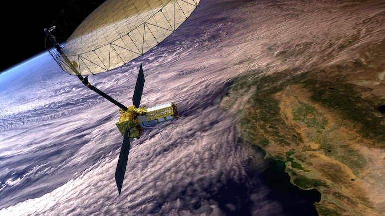
- NISAR is a joint NASA-ISRO Earth imaging satellite being launched on July 30 from Sriharikota
- The satellite weighs 2,392 kg and uses dual-frequency radar for all-weather Earth imaging
- NISAR data will aid disaster management, agriculture, climate monitoring, and ecosystem study
"NISAR is not just a satellite, it is India's scientific handshake with the world" says Science Minister Dr Jitendra Singh. This very unique Earth imaging satellite jointly made by India and America named the NASA ISRO Synthetic Aperture Radar (NISAR) satellite is a technological marvel and would be game changer in saving lives from impending natural disasters. That the world's oldest democracy USA and the world's largest democracy India are working together on this most expensive satellite that has cost upwards of 1.5 billion dollars to make is testament to the growing Indo-US bonhomie and strategic ties.
Describing it as a landmark moment for Indo-US space collaboration, Dr Singh says the NISAR mission, the first joint Earth observation initiative between the Indian Space Research Organisation (ISRO) and the United States' National Aeronautics and Space Administration (NASA), is being hailed as a transformative step in India's international scientific engagements.
Dr Singh described the launch as a significant milestone in India's growing stature as a global scientific power. "The July 30th launch of the NISAR' satellite from Sriharikota will upscale ISRO's international collaborations," he said, emphasising the mission's role in strengthening strategic scientific partnerships and showcasing India's capabilities in advanced Earth observation systems.
ISRO takes care of the satellite commanding and operations, NASA will provide the orbit maneuver plan and RADAR operations plan. NISAR mission will be aided with ground station support of both ISRO and NASA for downloading of the acquired images, which after the necessary processing will be disseminated to the user community. The data acquired will help the scientists to understand the changes happening to planet Earth.
He further underscored the mission's alignment with Prime Minister Narendra Modi's global vision: "This mission lives up to PM Modi's vision of India becoming a 'Vishwa Bandhu'-a global partner that contributes to the collective good of humanity."
Highlighting the broader implications of the mission, Dr Singh stated, "this mission is not just about a satellite launch - it is a moment that symbolises what two democracies committed to science and global welfare can achieve together. NISAR will not only serve India and the United States but will also provide critical data for countries around the world, especially in areas like disaster management, agriculture, and climate monitoring."
The NISAR satellite, weighing 2,392 kg, will be placed in a sun-synchronous orbit and will offer repeat imaging of Earth's land and ice surfaces every 12 days. It combines NASA's L-Band SAR and ISRO's S-Band SAR, mounted on a 12-meter deployable antenna. This dual-frequency radar system will enable high-resolution, all-weather, day-and-night imaging using Sweep SAR technology, covering a swath of 242 kilometers.
Dr Singh elaborated on the mission's wide-ranging applications: "It will allow continuous monitoring of ecosystem disturbances and help assess natural hazards such as earthquakes, tsunamis, volcanic eruptions, and landslides. It will track even subtle changes in the Earth's crust and surface movement. Importantly, the satellite's data will also be used for sea ice classification, shoreline monitoring, storm tracking, crop mapping, and changes in soil moisture-all of which are vital for governments, researchers, and disaster management agencies."
A key feature of the mission is its commitment to open data. "All data generated by NISAR will be made freely accessible within one to two days of observation, and in near real-time in case of emergencies," Dr Singh noted. This democratisation of data is expected to empower global scientific research and policy-making, especially in developing nations.
Dr Singh also highlighted the mission's technological significance: "Notably, the NISAR mission is the first time a Geosynchronous Satellite Launch Vehicle (GSLV) rocket is being used to place a satellite in sun-synchronous polar orbit, signaling ISRO's growing technical sophistication in supporting diverse space missions."
Reflecting on the mission's decade-long development and its 1.5 billion dollar joint investment, Dr Singh concluded, "Missions like NISAR are no longer confined to scientific curiosity - they are instrumental in planning, risk assessment, and policy intervention. As climate change impacts intensify, timely and accurate data from satellites like NISAR will be indispensable for governments to act proactively."
Track Latest News Live on NDTV.com and get news updates from India and around the world

