

With cyclone Fani having intensified into a extremely severe cyclonic storm, the Indian Navy today said it has started preparations to provide assistance in case of an emergency. The navy has prepared ships with additional divers, doctors, inflatable rubber boats and relief materials. The navy said that its aircraft are also standing by at air stations in Tamil Nadu and Andhra Pradesh to undertake reconnaissance, rescue, casualty evacuation and air drop of relief material to the stranded if required.
Cyclone Fani is headed towards the Odisha coast and is likely to hit south of Puri on Friday afternoon, the weather department said on Monday. Officials had earlier said that Fani can worsen into an "extremely severe cyclone" by tomorrow, prompting the government to put the National Disaster Response Force and the Indian Coast Guard on high alert.
Here are the live updates on Cyclone Fani:
"Fishermen have been asked not to venture into the seas from May 2. The tourists who are visiting the coastal areas of West Bengal, have been asked to stay away from the sea from May 2-4," the officials said.
All fishermen who have already gone to the deep seas, have been asked to return to the shore by Wednesday, and refrain from venturing into the waters till further notification.
The East Midnapore district administration has been asked to take all preventive measures and maintain strong vigil on the Digha, Mandarmani and other beaches so as to stop visitors from bathing on the three days on the turbulent sea. Water sports activities will also remain cancelled.
Fishermen associations have been advised not to sail any boat during the period.
"We have requested the Cabinet Secretary to position two helicopters for air-dropping relief material. Besides, we have asked for additional NDRF teams to carry out the rescue operation," said chief secretary A.P. Padhi.
Mr Padhi said the impact of the cyclone will be maximum on Odisha.
Indian Meteorological Department (IMD) has predicted that the cyclone will first hit Puri district after which it will move northwards towards Khurda, Jagatsinghpur, Cuttack, Kendrapada, Jajpur, Bhadrak, Balasore and Mayurbhanj, he added.
Padhi said the evacuation process will begin from the morning of May 2. People from low-lying areas will be evacuated to nearby cyclone shelters, schools and other safe places.
As many as 879 cyclone shelters are ready. Besides, 20 Odisha Disaster Rapid Action Force (ODRAF) units and 335 fire services units are on stand-by.
A total of 28 NDRF teams, including extra 10 teams, are rushing from outside Odisha to assist during the cyclone. They will be in propositioning locations cross coastal districts, said an official.
(i) Heavy rainfall warning
North Andhra Pradesh: Light to moderate rainfall at many places with heavy to very heavy rainfall at isolated places very likely over north coastal Andhra Pradesh (Srikakulam and Vijayanagaram Districts) on 2 nd May and rainfall at most places with heavy to very heavy
rainfall at a few places on 3rd May.
Odisha: Light to moderate rainfall at many places with heavy to very heavy rainfall at isolated places very likely over south coastal Odisha on 2nd May. It is likely to increase with rainfall at most places and heavy to very heavy rainfall at a few places with extremely heavy falls (>20 cm) at isolated places over coastal Odisha & its adjoining districts of interior Odisha on 3rd and over north Odisha on 4th May.
West Bengal: Light to moderate rainfall at most places with heavy falls at isolated places very likely over coastal districts of West Bengal on 3rd and heavy to very heavy rainfall at a few places with extremely heavy falls at isolated places over Gangetic West Bengal on 4th May.
(ii) Wind warning
Gale wind speed reaching 155-165 kmph gusting to 180 kmph is prevailing over Southwest and adjoining westcentral & Southeast Bay of Bengal. It is very likely to increase gradually becoming 175-185 kmph gusting to 205 kmph over Westcentral & adjoining Southwest Bay of Bengal off north Tamilnadu, Puducherry and south Andhra Pradesh Coast from 1 st May morning onwards.
Strong wind speed reaching 30-40 kmph gusting to 50 kmph very likely along & off Tamilnadu & Puducherry coast, Comorin area, Gulf of Mannar and Kerala on 30th.
Squally wind speed reaching 40-50 kmph gusting to 60 kmph is very likely to commence along & off north Andhra Pradesh & Odisha Coasts from 2nd May and very likely to become gale wind speed reaching 60-70 kmph gusting to 85 kmph from 3rd May morning and
become 175-185 kmph gusting 205 kmph over Odisha Coast and 90-100 kmph gusting to 115 kmph over adjoining districts of north Andhra Pradesh by 3rd May evening.
Squally wind speed reaching 40-50 kmph gusting to 60 kmph is very likely along & off West Bengal coast on 2nd May. It would become gale wind speed reaching 60-70 kmph gusting to 85 kmph from 3
rd May evening and become 90-100 kmph gusting to 115 kmph from 4th May morning.
(iii) Sea condition
The sea condition is phenomenal over Southwest Bay and adjoining Southeast & westcentral Bay of Bengal, off north Tamilnadu, Puducherry and south Andhra Pradesh Coasts. It is very likely to be phenomenal over westcentral Bay of Bengal during 1-3 May
2019 and over Northwest Bay of Bengal during 2-4 May.
Sea conditions very likely to be very rough to high along & off north Andhra Pradesh Coasts during 1-3 May and high to phenomenal along & off Odisha and West Bengal Coasts during 2-4 May.
(iv) Storm surge Warning
Storm surge of about 1.5 meter height above astronomical tide is very likely to inundate low lying areas of Ganjam, Khurda, Puri & Jagatsinghpur Districts of Odisha at the time of landfall.
(v) Fishermen Warning
The fishermen are advised not to venture into deep sea areas of Southwest & adjoining southeast Bay of Bengal on 30th April; Southwest & adjoining westcentral Bay of Bengal, along & off Puducherry, north Tamilnadu & south Andhra Pradesh coasts till 1st May; westcentral Bay of Bengal, along & off north Andhra Pradesh Coast during 1-3 May 2019 Spatial rainfall distribution: Isolated: <25%, A few: 26-50%, Many: 51-75%, Most: 76-100% Rainfall amount (mm): Heavy rain: 64.5 - 115.5, Very heavy rain: 115.6 - 204.4, Extremely heavy rain: 204.5 or more and northwest & adjoining Westcentral Bay of Bengal along & off Odisha and West Bengal coasts from 2-4 May.
Those, who are out in deep sea above areas are advised to return to the coasts.
(vi) (a) Damage Expected and Action suggested for Ganjam, Gajapati, Khurda, Puri, Jagatsinghpur districts of Odisha.
(i) Extensive damage to all types of kutcha houses, some damage to old badly managed Pucca structures. Potential threat from flying objects.
(ii) Extensive uprooting of communication and power poles.
(iii) Disruption of rail/road link at several places.
(iv) Extensive damage to standing crops, plantations, orchards.
(v) Blowing down of Palm and coconut trees.
(vi) Uprooting of large bushy trees.
(vii) Large boats and ships may get torn from their moorings.
Action Suggested:
(i)Total suspension of fishing operations.
(ii) Extensive evacuation from coastal areas.
(iii) Diversion or suspension of rail and road traffic.
(iv) People in affected areas to remain indoors.
(v) Movement in motor boats and small ships not advisable.
(b) Damage Expected and action suggested for Kendrapara, Bhadrak, Jajpur, Balasore districts of Odisha and east & west Medinipur, south & north 24 Parganas, Howrah, Hoogli, Kolkata districts of West Bengal and Srikakulam and Vijayanagaram districts of Andhra Pradesh
(i) Total destruction of thatched houses/ extensive damage to kutcha houses. Some damage to pucca houses. Potential threat from flying objects.
(ii) Bending/ uprooting of power and communication poles.
(iii) Major damage to Kutcha and and Pucca roads. Flooding of escape routes. Minor disruption of railways, overhead powerlines and signalling systems.
(iv) Widespread damage to standing crops, plantations, orchards, falling of green coconuts and tearing of palm fronds. Blowing down of bushy trees like
mango.
(v) Small boats, country crafts may get detached from moorings. (vi) Visibility severely affected.
Action Suggested:
(i) Total suspension of fishing operations. Mobilise evacuation from coastal areas.
(ii) Judicious regulation of rail and road traffic.
(iii) People in affected areas to remain
indoors.
The Very Severe Cyclonic Storm "Fani" over Southwest and adjoining Southeast Bay of Bengal moved northwestwards with a speed of about 21 kmph in last six hours and lay centred at 1430 hrs IST of 30th April, 2019 over Southwest and adjoining westcentral and Southeast Bay of Bengal near latitude 13.0°N and longitude 85.3°E, about 760 km south-southwest of Puri (Odisha) and 560 km south-southeast of Vishakhapatnam (Andhra Pradesh) and about 660 km
north-northeast of Trincomalee (Sri Lanka). It is very likely to intensify further into an Extremely
Severe Cyclonic Storm during next 06 hours. It is very likely to move northwestwards till 01st
May evening and thereafter recurve north-northeastwards and cross Odisha Coast between
Gopalpur and Chandbali, to the south of Puri around 3 rd May afternoon with maximum sustained wind of speed 175-185 kmph gusting to 205 kmph.
The National Crisis Management Committee (NCMC) met today for the second time in as many days and reviewed the preparedness with the States and concerned Departments of Government of India, to deal with the situation arising out of the Cyclonic Storm 'Fani', a press release by the Press Information Bureau said.
Based on the decision of the first meeting of NCMC, Centre has already releasedadvance financial assistance of Rs. 1,086 crore to Tamil Nadu, Andhra Pradesh, Odisha and West Bengal to assist them in undertaking preventive and relief measures, it said.
Reviewing the preparedness of the States and Central Agencies, Cabinet Secretary directed that all necessary measures be taken to prevent any loss of life and to keep in readiness essential supplies including food, drinking water and medicines etc. He also advised all concerned to make adequate preparations to ensure maintenance of essential services such as power, telecommunications in the event of damages caused to them. During the meeting, officers of all concerned State Governments confirmed their preparedness to deal with any emerging situation arising out of the cyclonic storm.
Indian Coast Guard and the Navy have deployed ships and helicopters for relief and rescue operations. Army and Air Force units in the three states have also been put on standby
NDRF is deploying total 41 teams - in Andhra Pradesh (8), Odisha (28) and West Bengal (5) - for prepositioning. In addition NDRF is keeping on standby 13 teams in West Bengal and 10 in Andhra Pradesh, the release said.
States have issued advisories and are ensuring that fishermen do not venture into the sea. IMD has been issuing three hourly bulletins with latest forecast to all the concerned States. MHA is also in continuous touch with the State Governments and the Central Agencies concerned.
"I am going to see the Chief Election Commissioner about postponing the election in the Patkura assembly seat in case the cyclone hits Odisha," Patnaik told reporters.
The ECI had earlier fixed May 19 as the date for the polling in Patkura assembly segment under Kendrapara Lok Sabha seat following death of BJD candidate Bed Prakash Agarwal on April 20.
The forecast that the cyclone may not hit the Andhra coast provided some relief to the administration as nearly 1,000 km long coastline is expected to escape the devastation, but north coastal Andhra comprising Visakhapatnam, Vizianagaram and Srikakulam districts bordering Odisha were still taking preventive steps.
Special officers in parts of Srikakulam district on Tuesday held a meeting with officials of various departments to review the situation. Authorities in coastal villages and low-lying areas were asked to remain on alert and undertake evacuation, wherever necessary.
Chief Secretary L.V. Subrahmanyam said the state was prepared to deal with any eventuality.
This quick & pre-emptive step will help Odisha,Tamil Nadu,West Bengal & Andhra Pradesh prepare better to brave #CycloneFani & minimise potential damages. Pray for the safety & well-being of people in Odisha and other coastal states likely to be affected by the cyclone.
- Chowkidar Dharmendra Pradhan (@dpradhanbjp) April 30, 2019
- The Odisha government is likely to begin the evacuation of people affected by cyclone Fani from May 2 as the severe cyclonic storm is heading to make a landfall on the state's coast, an official said.
- The state government has also asked the concerned district collectors in the coastal regions to remain prepared to meet any eventuality.
- As many as 879 cyclone shelters were already set up. Besides, 20 Odisha Disaster Rapid Action Force (ODRAF) units, 335 fire services and 12 NDRF units were on standby.
#CycloneFani Warning
- NDMA India (@ndmaindia) April 30, 2019
Source: IMD pic.twitter.com/V1rAaE2y3G
- The Severe Cyclonic Storm Fani (pronounced as 'Foni') over Southeast and adjoining Southwest Bay of Bengal moved north-northwestwards with a speed of about 16 kmph in last six hours, intensified into a Very Severe Cyclonic Storm and lay centred at 0530 hrs IST of 30th April, 2019 near latitude 11.7°N and longitude 86.5°E over Southeast and adjoining Southwest Bay of Bengal, about 670 km east-northeast of Trincomalee (Sri Lanka), 690 km east-southeast of Chennai (Tamil Nadu) and 760 km southeast of Machilipatnam (Andhra).
- It is very likely to intensify further into an Extremely Severe Cyclonic Storm during next 36 hours. It is very likely to move northwestwards till 01st May evening and thereafter recurve north-northeastwards towards Odisha Coast.
- Anticipating possible landfall in Bhadrak/Balasore region of Odisha NDRF team propositioned at Balasore and further strengthened with manpower and equipment especially tree cutters.
- Jharkhand RRC alerted to be on hot standby. All teams at Mundali on ready standby.
Cyclone Fani may intensify further today, Navy on high alert https://t.co/ltlyeryfQA pic.twitter.com/GQq7CkOJwU
- NDTV Videos (@ndtvvideos) April 30, 2019
Reviewed @SRC_Odisha's preparedness as cyclone #Fani has turned course to pass through coast of #Odisha. Also discussed with senior officials on the preparedness of the field officials. Administration is fully geared up to handle the situation.
- Naveen Patnaik (@Naveen_Odisha) April 30, 2019
#CycloneFani to turn into an Extremely severe cyclonic storm. It lies abt 700 kms east south east of chennai and 760 kms southeast of Machilipatnam. Likely to move northwestwards till 1 May and then recurve northeastwards towards Odisha Coast. - IMD pic.twitter.com/nkzTnzuqMP
- NDMA India (@ndmaindia) April 30, 2019
Cyclonic storm #Fani intensifies over Bay of Bengal. It may hit Andhra Pradesh-Odisha coast on May 3. Here are some of the dos and don'ts pic.twitter.com/sjzDiE0SGu
- NDTV (@ndtv) April 30, 2019

#CycloneFani pic.twitter.com/QuMwlIVKrq
- NDMA India (@ndmaindia) April 30, 2019
Naval aircraft are also standing by at the Naval Air Stations INS Rajali at Arakkonam, Tamilnadu and INS Dega at Visakhapatnam, Andhra Pradesh to undertake reconnaissance, rescue, casualty evacuation and air drop of relief material to the stranded if required 4/4 pic.twitter.com/OsdawHII50
- SpokespersonNavy (@indiannavy) April 30, 2019
These ships are embarked with additional divers, doctors, inflatable rubber boats & relief material that include food, tentage, clothes, medicines, blankets etc, in quantities sufficient 3/n pic.twitter.com/6pv6ad3On8
- SpokespersonNavy (@indiannavy) April 30, 2019
Indian Naval ships at Visakhapatnam & Chennai are ready & standing-by to proceed to the most affected areas to undertake Humanitarian Aid Distress Relief (HADR), evacuation, logistic support including providing medical aid. 2/n pic.twitter.com/N4laeFJ9zb
- SpokespersonNavy (@indiannavy) April 30, 2019
#CycloneFani As the cyclone storm FANI intensifies into a Severe Cyclonic Storm over SE & adjoining SW Bay of Bengal & lie about 770 km ESE of Chennai at 1730 h/ 29 Apr, the Eastern Naval CD (ENC) has assumed high degree of readiness 2 render necessary humanitarian assistance 1/n pic.twitter.com/zDpZLEUpuU
- SpokespersonNavy (@indiannavy) April 30, 2019
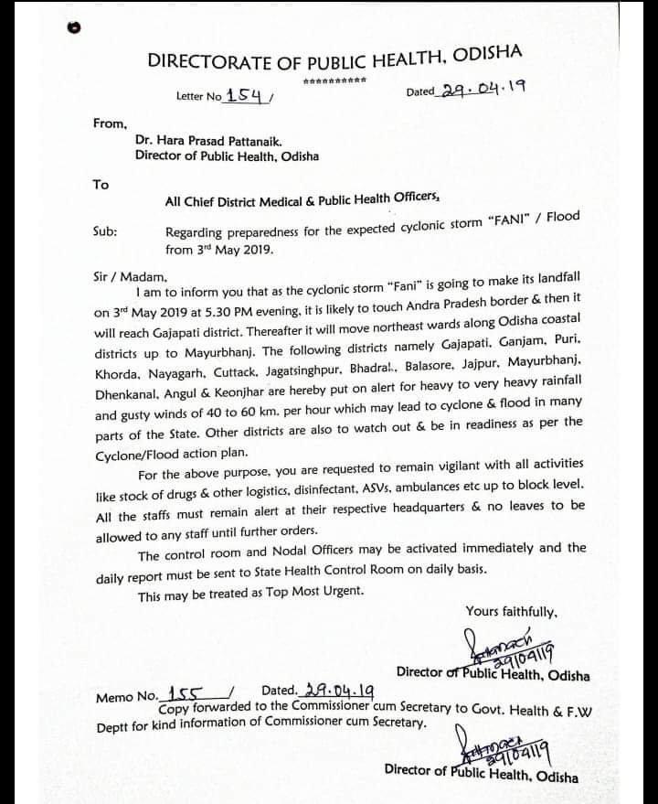
- The Directorate of Public Health of Odisha Hara Prasad Pattanaik on Monday alerted all chief district medical and public health officers regarding preparedness for the cyclonic storm 'Fani'.
- Mr Pattanaik informed that the cyclonic storm is going to make landfall on May 3 at 5.30 pm and is likely to touch Andhra Pradesh border and later reach Odisha's Gajapati, Mayurbhanj, Ganjam, Puri, Khorda, Nayagarh, Cuttack, Jagatsinghpur, Bhadrak, Balasore, Jajpur, Dhenkanal, Angul, and Keonjhar.
- All these districts have been put on high alert due to heavy rainfall and gusty winds of 40 to 60 kmph, which may lead to cyclone and flood in many parts of the state.
- According to IMD's forecast, ''Fani'' was located at 880 km south-east of Chennai as it continues to move North-West and is predicted to change its path to North-East from Wednesday.
- Fishermen in coastal areas have been advised to not venture into the sea.
- In Odisha, the government has asked fishermen who are out in deep sea areas to return to the coast by the night of April 30.
- The central government is keeping a close watch on the impact of the cyclonic storm on the states along the eastern coast.
