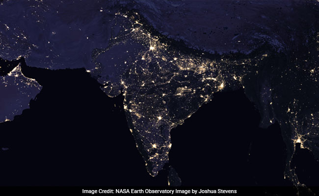
Here's what India looked like in 2016, according to NASA's composite night-time imagery
New Delhi:
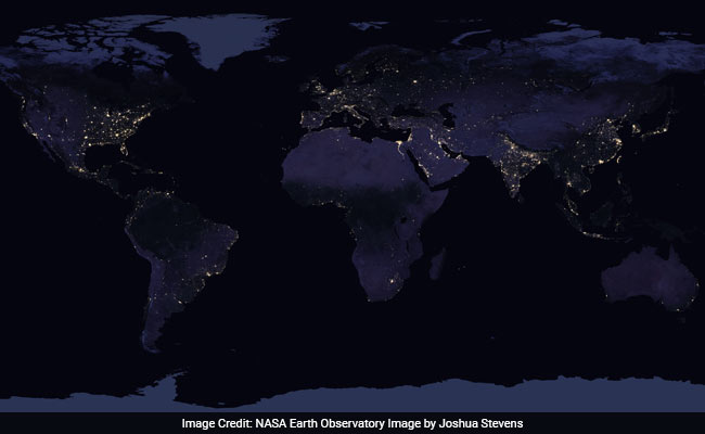
NASA has just released new global maps of the Earth at night - the first since 2012. The stunning satellite images of Earth at night, referred to as "night lights," have been released every decade or so for nearly 25 years. Now, NASA scientists are trying to see if the night lights imagery can be updated more frequently - perhaps even daily. Doing so would drastically change how we forecast weather, improve natural disaster responses and even help track the effects of war.
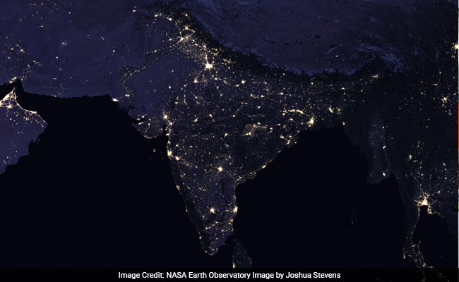
Take a look at these two images of India showing how cities have grown and populations have spread in the past few years. The image below is from 2016. Compare it to the the second one from 2012.


Earth scientist Miguel Roman of NASA's Goddard Space Flight Center is leading the research team that has been developing new software and algorithms to provide the clearest, most accurate images possible. This year's images eliminate light from the moon, which varies the amount of light shining on the Earth. According to the US space agency, the team wrote code that picked the clearest night views each month, ultimately combining moonlight-free and moonlight-corrected data.
The composite images are the result of data from the Visible Infrared Imaging Radiometer Suite (VIIRS) on the NASA-NOAA Suomi National Polar-orbiting Partnership (NPP) satellite. According to NASA, VIIRS is the first satellite instrument to make quantitative measurements of light emissions and reflections, which allows researchers to distinguish the intensity, types and the sources of night lights over several years.

"Thanks to VIIRS, we can now monitor short-term changes caused by disturbances in power delivery, such as conflict, storms, earthquakes and brownouts," says Roman. "The fact that we can track all these different aspects at the heart of what defines a city is simply mind-boggling."
Click here for more trending stories.
Take a look at these two images of India showing how cities have grown and populations have spread in the past few years. The image below is from 2016. Compare it to the the second one from 2012.

NASA released this composite night-time view of India and surrounding areas from 2016

This composite night-time view of India and surrounding areas is from 2012
Earth scientist Miguel Roman of NASA's Goddard Space Flight Center is leading the research team that has been developing new software and algorithms to provide the clearest, most accurate images possible. This year's images eliminate light from the moon, which varies the amount of light shining on the Earth. According to the US space agency, the team wrote code that picked the clearest night views each month, ultimately combining moonlight-free and moonlight-corrected data.
The composite images are the result of data from the Visible Infrared Imaging Radiometer Suite (VIIRS) on the NASA-NOAA Suomi National Polar-orbiting Partnership (NPP) satellite. According to NASA, VIIRS is the first satellite instrument to make quantitative measurements of light emissions and reflections, which allows researchers to distinguish the intensity, types and the sources of night lights over several years.

NASA has released a new global composite map of night lights as observed in 2016
"Thanks to VIIRS, we can now monitor short-term changes caused by disturbances in power delivery, such as conflict, storms, earthquakes and brownouts," says Roman. "The fact that we can track all these different aspects at the heart of what defines a city is simply mind-boggling."
Click here for more trending stories.
Track Latest News Live on NDTV.com and get news updates from India and around the world

