
The full extent of a massive volcanic eruption in Tonga that triggered tsunami waves around the Pacific is apparent in new satellite images that show the aftermath of the extensive damage caused by the disaster.
Three days after the volcanic eruption, early indications of the scale of the crisis on the virtually cut-off Pacific island kingdom have emerged through images released by US-based Maxar. They show the impact of the large eruption of the Hunga Tonga Hunga Ha'apai volcano as well as the damage caused by the tsunami in the nearby Tongan capital of Nuku'alofa.
The images also clearly show that most of the volcanic island that used to be above water was destroyed by the eruption and volcanic debris can be seen floating in the ocean.
The eruption on Saturday was so powerful it was recorded around the world, triggering a tsunami that flooded Pacific coastlines from Japan to the United States.
Ashes from the volcano covered many of the homes and buildings across Tonga while damage from the tsunami is evident near the main port facilities in Nuku'alofa.

Overview of Hunga Tonga Volcano before main eruption.

Overview of Hunga Tonga Volcano before main eruption.

Closer view of Hunga Tonga Volcano Before Main Eruption.

Overview of Hunga Tonga Volcano after main eruption.
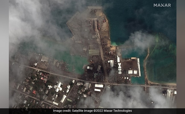
Main port facilities after eruption and tsunami at Tongan capital Nuku'alofa
Track Latest News Live on NDTV.com and get news updates from India and around the world

