Opinion | 482 Dead, And Counting: How A Glacier Collapse Became A Himalayan Disaster
What looks like a sudden flood is actually the final link in a chain of events unfolding across an increasingly unstable Himalayas
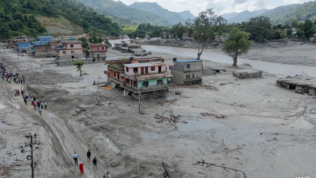
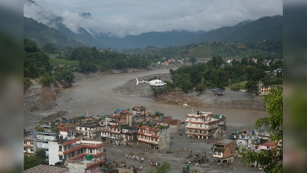
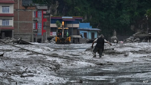
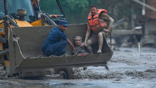
The Himalayas gave us a brutal reminder this week of what climate change looks like when it stops being a graph and becomes a wall of water, ice, rock, and mud. Across the Nepal-Tibet border, a sudden glacier collapse unleashed a catastrophic flood that tore through communities, roads, bridges, and power infrastructure. Rescue operations are still underway, with at least 482 people confirmed dead so far, and the toll expected to change. But one thing is already clear: this was not an ordinary monsoon flash flood.
Early assessments point to an ice-rock avalanche or glacier collapse that turned into a massive debris flow, rather than a conventional glacial lake outburst flood. The US Geological Survey later said the seismic signal first reported as an earthquake was generated by a glacial collapse and debris flow, not by tectonic shaking.
The Tipping Point
Scientifically, the distinction matters. Politically and morally, it changes little. The Himalaya is turning into a more unstable landscape, and climate change is making it worse. The Global Tipping Points Report 2025, led by the University of Exeter's Global Systems Institute and more than 160 researchers, says tipping-point risks rise as warming approaches and exceeds 1.5 degrees Celsius. Mountain glaciers, it notes, are among the systems capable of nonlinear responses under continued warming. Tipping points do not act alone. Most interactions between the systems assessed are destabilising. One shift can make another more likely, pushing ecological and human systems into cascading risk.
The concern, then, goes far beyond the valleys hit this week. A warming glacier does not simply become a smaller glacier. It can become a different kind of threat altogether. As glaciers retreat, meltwater collects in lakes, often held back by unstable walls of ice, rock, and moraine. These lakes can expand quickly. A sudden avalanche, landslide, ice collapse, or breach can release huge volumes of water and sediment downstream. In steep Himalayan valleys, gravity does the rest.
A regional analysis of 5,409 Himalayan glacial lakes found both their number and area increasing between 1990 and 2020, with expansion concentrated in parts of the central and eastern Himalaya. Studies of supraglacial lakes tell a similar story of restless ice and water. These are not abstract risks on a map. They are forming above real villages, roads, bridges, hydropower projects, and pilgrimage routes.
Different Consequences
The danger is already built into the landscape. More than 5,000 glacier lakes exist across the region, and work on Himalayan GLOF hazard suggests that a 100-year outburst flood could send peak flows downstream comparable to major monsoon-fed rivers. The glaciers are shrinking too. A Scientific Reports reconstruction of 14,798 Himalayan glaciers found that they had lost at least 40% of their Little Ice Age area, with recent mass-loss rates roughly an order of magnitude faster than the long-term average since then.
Climate change does not mean every kind of glacial lake outburst flood will become more frequent in a neat, linear way. A Nature Climate Change study found no statistically significant increase in moraine-dammed GLOFs in the Himalaya since the late 1980s. The terrain, however, is changing: its exposure, triggers, weak points, and consequences.
That is a harder problem, and probably the more dangerous one. We are building roads, dams, tunnels, hotels, and settlements in a mountain system that is no longer behaving according to old assumptions. Himalayan valleys are narrow, and they leave little room for engineering arrogance. Traditional climate risk assessment is not built for such nonlinear behaviour. Tipping-point risks involve uncertainty, sudden shifts, and cascading impacts. For South Asia, the stakes are enormous. More than three billion people depend on vulnerable monsoon systems, while Himalayan rivers, glaciers, and mountain ecosystems support farms, towns, hydropower, and economies far downstream.
Asking The Wrong Questions
The ritual question after every disaster is whether climate change "caused" it. That is often the wrong question. The better one is whether climate change is making the landscape more capable of producing disasters that were previously rarer, smaller, or easier to manage. Increasingly, the answer is yes.
This is the choice before us. Tip the energy system away from fossil fuels. Tip infrastructure planning towards climate resilience. Build real-time glacier and glacial-lake monitoring across borders. Create early-warning systems that actually reach the people living downstream. And stop treating Himalayan valleys as empty spaces waiting for another road, dam, or resort.
Regional cooperation, therefore, cannot remain hostage to political weather. Rivers, glaciers, and debris flows do not stop at lines on a map, nor do they wait for diplomatic relations to improve. India, Nepal, Bhutan, Pakistan, Bangladesh, and China need shared glacier data, joint hazard mapping, open hydrological information, and disaster-warning protocols that work even during periods of interstate tension. In the high Himalaya, a warning delayed by suspicion can become a warning delivered too late.
(Shailendra Yashwant is an environmental researcher and adjunct fellow at Sunway Centre for Planetary Health, Malaysia)
Disclaimer: These are the personal opinions of the author
-
Opinion | Rahul Gandhi Is Cleaning House - But At The Cost Of The Congress

In his search for a new organisation, Rahul Gandhi is making the big mistake of treating the Congress he inherited as dead weight.
-
One-Day Disaster, Multi-Season Economic Shock: Nepal's Sisyphean Curse
Nepal Flash Floods: Nepal cannot prevent every earthquake, landslide or glacial collapse. But it can reduce how much each disaster costs.
-
Meta Pays Billions Over Teen Harms In US. In India, Algo Runs Unchecked
The US Surgeon General has separately warned that heavy social media use roughly doubles adolescents' risk of depression and anxiety, and that nearly half of teens surveyed said it made them feel worse about their bodies.
-
Blog | 'No Calls, People Scanning Banks For Bodies': Nepal Journalist Describes Flood Aftermath
As of Thursday evening, it was still impossible to get through to mobile phones in Dhunche, the district headquarters, or the flood-ravaged towns of Syabru Bensi or Timure.
-
Opinion | Toxic Knows Exactly What It Is Doing To Its Hero. And You May Have Missed It
Toxic's bait-and-switch goes beyond its plot. Geetu Mohandas is almost making a subtle point - for those who can see it.
-
Why Nepal Is So Vulnerable: Glacial Lakes, And A Himalaya That Moves Constantly
The August 26 inland tsunami was not an accident of weather. It sat at the intersection of processes that make Nepal one of the most hazard-exposed countries.
-
IRGC's New Boss Is No Ordinary Man. Meet Ahmad Vahidi, Iran's Ultimate Survivor
He has survived purges, sanctions, assassinations, secret deals, and Iran's most consequential wars. The IRGC's new chief, formally appointed by Khamenei this month, knows the regime - and its enemies - like few others do.
-
Analysis | BJP's Mother Of All Resets: An Overhaul To Fix Its Perception Problem
The battle this time is to regain credibility as BJP has entered a phase which is going to be the launch pad for a national face after a political force called Narendra Modi.
-
Opinion | Why Is India Cooler As The World Burns? A Heatwave 'Mystery'
Europe, which is warming at more than twice the global average, is now bracing for even worse climate impacts. But something strange and unexpected is happening in India, keeping it cooler.