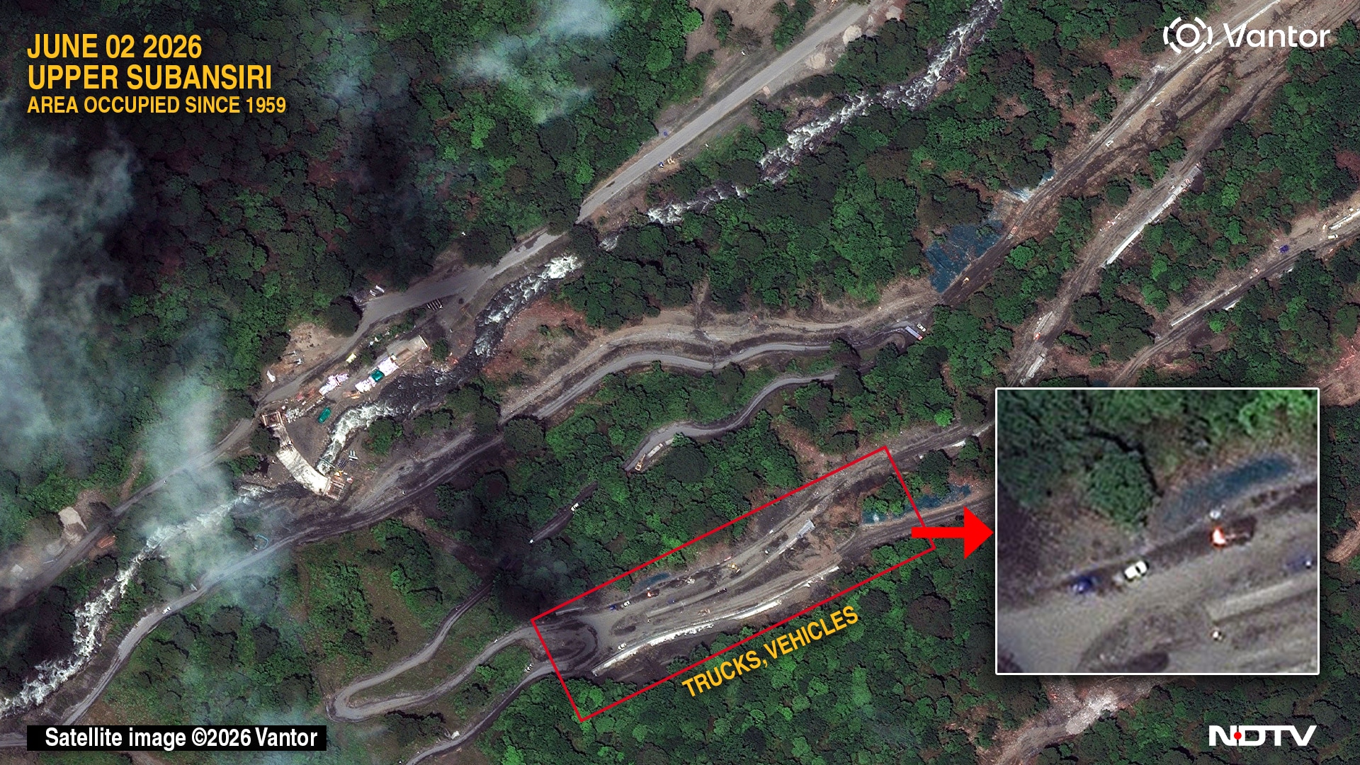
A review of high-resolution satellite imagery shows China constructing a new road along a part of the Tibet-India frontier along Arunachal Pradesh that India does not control. The area, however, falls within the McMahon Line, the historic boundary shown by the Survey of India on its official maps.
India and China have significant differences in perception over the coordinates of the boundary line in this area.
While India has never given up its claim to the region which was lost to China in 1959, sources said it presently lies "beyond the Line of Actual Control (LAC)". In other words, beyond the line that the Indian Army physically patrols and defends.
Advertisement - Scroll to continue
In 2021, NDTV identified a new Chinese village with approximately 50 structures which had been constructed in the area.
The new road described in this report links this habitation with a new village that China has recently constructed 9.42 km to the west.
New Chinese road construction links a village built this year with the image above, a village constructed in 2021 on territory held by China since 1959. High res here
The bulk of the new habitation lies in uncontested Chinese territory, narrowly across India's official boundary line showing Arunachal Pradesh, though a construction plant and two helipads appear to be within India's original claim-lines. However, this cannot be confirmed since the boundary between India and China has never been officially demarcated.
Trucks and other vehicles on a road built by China in the Arunachal Pradesh border area it controls since 1959. High res here
The area which lies in Arunachal Pradesh's Upper Subansiri district came into sharp focus earlier this week when a welfare society, representing the Nah tribal community in the district, submitted a memorandum to the deputy commissioner alleging that China's People's Liberation Army (PLA) has occupied parts of their ancestral grazing, hunting and agricultural lands along the India-China border over the last six years.
The memorandum claims that China has built roads, camps and other infrastructure in the disputed areas.
With inputs: Damien Symon. High res here
"... India is confronting a sustained Chinese campaign to incrementally redraw the Line of Actual Control by constructing military outposts and militarised frontier villages, all linked by new roads across the high-altitude frontier," strategic affairs expert Brahma Chellaney told NDTV.
New Chinese village constructed in 2026 lies approximately 9 km west of Chinese village constructed by 2021. The new habitation features multiple homes, two helipads, a cement construction plant and a basketball court. High res here
In a statement, the Indian Army has rebutted these claims. "We have seen some media reports alleging recent encroachment by Chinese PLA and setting up of camps in Arunachal Pradesh. These reports are incorrect and without any basis."
Concerns over China's encroachment in parts of Arunachal Pradesh are not new. In November 2019, the BJP MP Tapir Gao, had said in the Lok Sabha, "I want to tell media houses in the country that there is no coverage of the extent to which China has captured Indian territory (in Arunachal Pradesh)."
Referring to the India-China standoff in Doklam in 2017 which lasted several months, Gao warned, "If there is another Doklam, it will be in Arunachal Pradesh."
The new village shown in this report has been under development since 2024 and is linked by a road network "ranging from freshly excavated sections to graded and paved segments," with "several branches" extending "toward other locations, including a route toward the perceived border with India."
Red box on top shows an excavator digging soil and dumping it on a truck. High res here
The older village "remains supported by military positions immediately to its south, including multiple helipads and posts that were visible in imagery dating back till 2013," notes geospatial intelligence researcher Damien Symon, while the new settlement "also features two helipads," with "numerous completed buildings" showing "vehicles parked adjacent to individual structures," and solar panel installations "indicating that at least part of the settlement is already occupied or is being prepared for occupation."
High res here
Cartographic ambiguity underlies the dispute in the region - while Google Maps displays the Survey of India boundary to users in India, it presents a different international boundary to users in most other countries. This variation is attributed to "differing representations of the McMahon Line," whose "alignment is understood differently across several widely used global mapping datasets," says Symon. Indian mapping platforms, including Bharatmaps, follow the Survey of India depiction.
India's Infrastructure Push In Arunachal Pradesh
India is running an ambitious, strategically-driven infrastructure buildout in Arunachal Pradesh in response to Chinese construction activity along the Sino-Indian boundary. The centerpiece is the Arunachal Frontier Highway (NH-913), a 1,748-km road stretching from Bomdila to Vijaynagar. This runs as close as 20 km from the border to enable troop mobility and surveillance of Chinese activity.
Costing around Rs 40,000 crore and including 800 km of greenfield construction plus new tunnels and bridges, it's being built in nine packages with completion targeted for 2029. Six additional connecting corridors totaling 2,178 km will link it to the existing Trans-Arunachal Highway and East-West Industrial Corridor.
Parallel to this is the Vibrant Villages Programme (VVP), aimed at developing remote border settlements to prevent depopulation. The first phase of the programme targets 662 villages across five border states with a Rs 4,800 crore outlay, funding roads, tourism projects and public infrastructure.
The second phase has expanded coverage to more states with a Rs 6,839 crore budget through 2028-29. In Arunachal specifically, feeder roads are being built to 122 border villages (Rs 2,205 crore), alongside 1,022 km of VVP-approved roads and community centres.
Additionally, the Border Roads Organisation (BRO) has launched dozens of projects (including the completed Sela Tunnel) connecting remote outposts to the highway network. This infrastructure expansion directly counters China's construction of more than 600 "defence villages" and new airfields along the border, with the aim of halting rural out-migration and strengthening India's physical presence on the ground.