- Satellite images show the Rapid Support Forces (RSF) conducting mass killings in El-Fasher
- Sudan has experienced conflict between the army and RSF for more than two years
- According to the United Nations, the war has killed around 40,000 people and displaced 12 million others
There's been so much bloodshed in war-ravaged Sudan that it is visible even from space. Satellite images from the Yale School of Public Health's Humanitarian Research Lab (HRL) show a rebel organisation conducting mass killings after capturing El-Fasher last week.
Sudan has been ravaged by a deadly civil war for more than two years. The war between the Sudanese Army and the Rapid Support Forces (RSF) began in April 2023, when the two units, previously sharing power, fell out over plans to integrate their forces during a transition towards democracy.
On October 26, the RSF said that it captured the army headquarters in the city of El-Fasher, North Darfur. The city had been the last stronghold of the army in Darfur.
READ: Rebel Groups' Capture Of Sudan's El-Fasher Sparks Fears Of Mass Killings
According to the United Nations (UN), the war has killed around 40,000 people and displaced 12 million others.
The fighting has displaced millions, plunged half of Sudan into hunger, and spread disease throughout the country.
Evidence Of Mass Killings
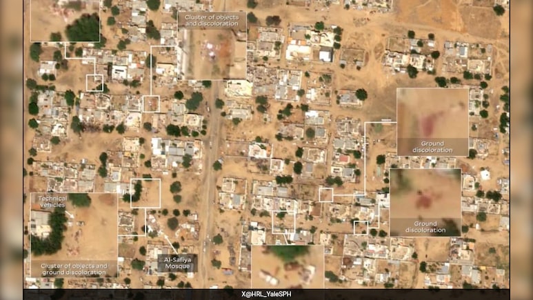
In a report published on Monday, Yale HRL observed RSF vehicles deployed in tactical formation consistent with house-to-house clearance operations in El-Fasher's Daraja Oula neighbourhood, where civilians have sought refuge as recently as last week.
🚨HUMAN SECURITY EMERGENCY🚨
— Humanitarian Research Lab (HRL) at YSPH (@HRL_YaleSPH) October 27, 2025
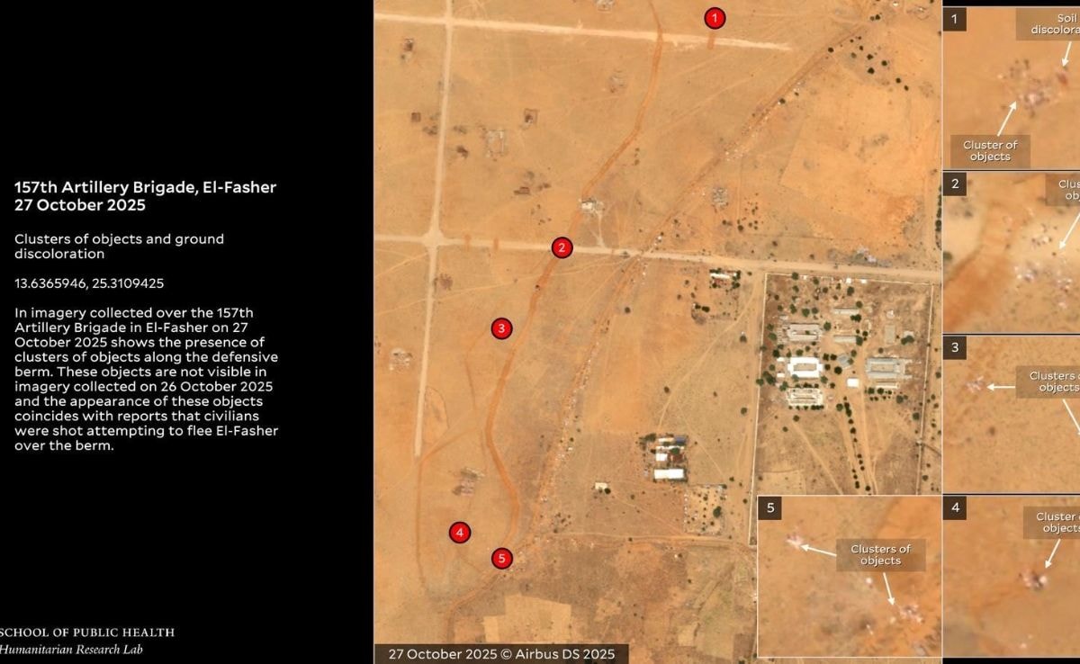
El-Fasher has fallen to RSF. HRL finds evidence of mass killings including door-to-door clearance operations and objects consistent with reported bodies on berm entrapping El-Fasher.#KeepEyesOnSudan
🛰️@AirbusSpace @Maxarhttps://t.co/1HApllgNL5 pic.twitter.com/yrCbM5HxeP
"Imagery analysis shows objects consistent with the size of human bodies on the ground near RSF vehicles, including at least five instances of reddish earth discoloration," the report said.
"House-to-house clearance operations are approximately 250 meters from Al Safiya mosque - which the RSF attacked in a drone strike on 19 September 2025 that killed approximately 78 people- and slightly northwest of the Saudi Hospital," the report added.
READ: UAE Refutes Sudan's Claim About Destroying Emirati Plane Carrying Mercenaries
Through credible information, Yale HRL also found out reports of civilians dying while fleeing El-Fasher.
People Flee RSF-Controlled Camps
Yale HRL said that groups of people could be seen leaving El-Fasher south towards the RSF-controlled Internally Displaced Persons (IDP) camp and west towards Tawilah.

"Large groups of objects consistent with people are visible south of El-Fasher on the B26 road to RSF-controlled Zamzam, formerly one of the largest IDP camps in Sudan. This area is totally under RSF control and has been used as a base of operations for RSF, the Yale report further said.
Control Of Major Military Installations
The final finding of the Yale report confirms the RSF taking control of the Sixth Division of the Sudanese Armed Forces (SAF).
Satellite images revealed that significant damage was visible at the Sixth Division headquarters. The images also showed additional RSF-consistent vehicles present at the premises.
Track Latest News Live on NDTV.com and get news updates from India and around the world

